 Sunset over Mt. Whitney and the Eastern Sierras, April 3, 2010

Spring flowers in Death Valley, April 6, 2010
It was Thursday, April 1st (Polly and Chris' 6th anniversary .. see about that in the last post), and we had visited Ontario, California, my father's boyhood and my parents early married life home (see Roots!). We had thought that we would head back up to central California and catch Yosemite, but the forecast scared us off: snow. I had made a reservation for Easter Brunch on the 4th at that beautiful Ahwahnee Hotel, and unfortunately they had a 7 days cancellation policy, so we hoped someone else enjoyed our Mimosas and eggs benedict!
We felt if we headed toward Death Valley we could adapt to the weather; there certainly wouldn't be snow there! Interstate 15 passes right through Ontario, so it was easy to pick it up going northeast. We knew we wanted to go north along the base of the eastern Sierra Nevada mountains on US 395, and there weren't a lot of RV camping choices along there. So we set Lone Pine as our goal, but needed an intermediate stop. We picked the KOA in Barstow, right on I15, and we would have to backtrack a bit to the 395 junction. But I saw on the map that Calico, the ghost town was nearby, and I remembered going there as a girl. So we had to go and did on
Friday, April 2nd.

Calico was an actual old west silver mining town. It boomed in 1881 through 1887, and one of the most interest facts was the population: 1881 - 40; 1882 - 300; 1887 - 1200; 1893 - 300; 1951 - 10; 2001 - 8. "Like most towns of the early West, when the price of silver dropped from $1.31 an ounce to 63 cents, Calico became a ghost town." Calico was preserved by Walter Knott of Knott's Berry Farm, and in 1966 he donated it to the County of San Bernardino.


 We looked at all the old time buildings, had a good BBQ lunch, and had the most fun in the games and puzzles store, which had a wonderful selection of complex wood puzzles. Gary picked up some real challengers which he enjoys.
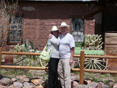
Back down by the highway was Peggy Sue's diner. Apparently it's famous along I15 in Barstow. Their gift shop had unbelievable 50's memorabilia, and this fountain set-up featured a soda jerk that looked like Michael Jackson. The actual diner, on the right, was also completely decked out in 50's stuff.


We found our way back to the junction of I 15 and US 395, and headed north. Gradually we saw the Sierra Nevada's start to rise higher and higher on our left, to the east. The mountains got higher and higher and more majestic, with more and more snow caps. We were so pleased to find Boulder Creek RV Resort at the south end of Lone Pine which was very nice with all the services we wanted. They couldn't help it that there was minimal cell phone service (in general we have run into more and more problems with AT&T coverage in the rural southwest; but I hear people complain about Verizon, too. I don't know.) It was pretty chilly that night in the shadow of Mt. Whitney.
Saturday, April 3rd was the day we drove to Bishop and Mammoth Lakes in the car. I wrote about some of the return to this area in Roots! as my family had vacationed here in the mid-'60s. We passed through Lone Pine and looked up to see Mt. Whitney looming down on us. You may remember that before Alaska was a state, Mt. Whitney was the tallest peak in the United States at 14,505 feet. My good friend, Carolyn Hebbel, has climbed it about 10 times I think. That's impressive! (up and down from the portal in a day, leaving about 5 in the morning!)

Lone Pine also has a Cowboy Movie museum, because a bunch of cowboy movies were made in the area. They've had cowboy film festivals here, and it's even the theme of a great afghan which we had to have (see below).
We drove north to Bishop looking for the Stephen Willard print, shopping at the Toggery, and ending up at Mammoth Lakes and seeing the snow capped Crystal Crag. There definitely was more and more snow as we went up 395, and it reminded us what we would have been in for had we gone to Yosemite. Here, the valley towns are lower and only subject to rain, but in Yosemite we might have had to go in and out of the valley on treacherous roads, so we were glad we chose the eastern slopes.


On the way back to Lone Pine, we stopped at Keough's Hot Springs which is the largest hot springs pool in the Eastern Sierras. The historic pool was built in 1919 and is kept at 104 degrees. It was fun popping back and forth in the near freezing air to the even hotter therapy pools and back to "cool off" and do chin-ups! Sorry the close up is out of focus, but I was just about running to get back into the water!


They had a little new age/spa product gift shop, and Liz wanted to start practicing her massage skills (fine with us!!). So she got "Lizard Lustre" lotion (we're calling her Lizard sometimes), and a spray called "Sleep Soother." Gary got a very zen bamboo wind chime that he put up by his driver's seat when he's not driving, i.e. when we're parked.
We stayed until about 7 pm, and as we drove back to Lone Pine caught the western sun going down behind Mt. Whitney and its neighboring peaks. It was lovely, and I wanted to leave it up top to represent the Eastern Sierras. Tomorrow we would drive east, over the Panamint Mountains into Death Valley.
Sunday, April 4
Sunday was a day we avoided trouble because of Gary's gregariousness in the RV parks. I stay a little more to myself (I'm never going to see these people again, and I'm, surprisingly, not much on visiting with strangers just for the fun of it). Anyway, Gary was visiting with one of our neighbors who had a similar size motorhome, and he said we shouldn't drive the motorhome down the steep, curvy road which enters Death Valley from the west. He suggested we cross the Panamint Mountains in the car, see what we wanted to see in the west and north side of Death Valley, and then drive the motorhome around to the south entrance and park it or drive it in from that direction. It sounded like a good idea to us.
We drove through Lone Pine, and then headed east and up into the mountains. At the summit, there was Father Crowley overlook, The Padre of the Desert who had ministered in the early part of the last century to folks in the Eastern Sierras and Death Valley. The view is impressive:

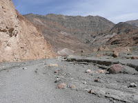
It is such an area of contrasts. Remember, the day before we were looking at the highest point in the lower 48 states, and today we were traveling to the lowest, Death Valley. Everywhere one looks you see evidence of the work of water and erosion and various geologic levels being laid down one on top of another. These were some of the vistas we saw on our drive to Stovepipe Wells.


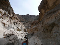
We checked out the various hikes (it was a pretty nice day, in the high 70's), and chose the hike up Mosaic Canyon, a marble rock canyon (i.e. slippery!). Its description was a little concerning to me as it said one would need to scramble and climb up rock, something I wasn't sure I could do after my knee surgery. But with the help of a nice walking stick Gary had bought me in Yosemite two years ago, I did quite well. It was beautiful.


The little brown lizard you see on the right is a chuckwalla (although the one we saw here had stripes on its back, and the brochure showed the chuckwalla without stripes).
It was interesting to see up close the very different layers from very smooth marble and coarse aggregate. Particularly note the background behind Liz in the picture on the right. The big picture is just of our hiker!


Stovepipe Wells is at Sea Level (see sign). Just beyond it is the Salt Creek Interpretive Trail where, when we looked hard, we could see the tiny pupfish, descendants of creatures that flourished in the basin's ancient lake at least 12,000 years ago. The spiky plants on the right look stuck on the desert floor as so much of the surrounding, supportive topsoil has been wind swept away.


The sand dunes were also impressive.


We drove home through Emigrant Pass to Wildrose, and then took a dirt road to the Panamint Valley. The clouds and setting sun's shadows made an interesting additional pattern to these already beautifully patterned mountains. It was such an interesting day, and even though there is a lot about Death Valley (including the name!) that sounds forboding, it is an eerily beautiful and extraordinarily interesting place. We planned to see some more entering from the south in another day or two.


Monday, April 5
It was a bright morning when we drove back south on US 395 on our way to the south entrance of Death Valley. In the Boulders RV Resort office, we had seen a very cool afghan celebrating the charms of Lone Pine. Even though the sign said they were on sale there, actually they were sold out. But the attendant kindly called around and discovered they were still on sale (they were first made about 8 years ago, I think) at the Lone Pine Drug Store. Indeed they were; they asked for cash as the proceeds go to a local philanthropy. You can see it is very cool, with Mt. Whitney, cowboy movies, etc.

It had rained the night before in Lone Pine, and so the snow level on the mountains was lower as we travelled south. It was unbelievably windy, and Gary once again did a phenomenal job driving that 40' bus down a two lane road like a professional. We moved down to Kramer Junction colloquially called four corners (where 58 goes east from US 395), and turned east. We were struck as we moved down the road and hit Interstate 15 with the spontaneous dust storms that sprung up all around us, all the time. It is the Mojave Desert, after all.


We turned off I15 at Baker (just after Zzyzx Road!)
and headed up 29 to Tecopa. I particularly wanted to go there because, again, it was a memory from the past. My mother's sister, my Aunt Dorothy and her husband Uncle Roy LOVED the desert, and used to pull their darling Airstream trailer to the California desert from Oregon, and for a number of years, that was Tecopa Hot Springs. I saw that this was just outside Death Valley, and we made that our target.

The springs pools are divided into men's and women's bath houses. I remember going in the women's bath house back in my early 20's with my mother and Aunt Dorothy. One goes in nude, and this was the first time I had been nude with other adult women. The baths are said to be healing, and it was the first time I had ever seen a woman with a surgically removed breast. It was very startling .... and I never forgot it.
I was told at this visit that "the international spa community has the unofficial opinion that Tecopa's natural water is rated best in the world"; formerly it was thought that Baden-Baden in Germany was the best, but now Tecopa enjoys that ranking!


We had to delicately handle the issue of nude bathing with Liz. She wasn't at all sure she was ready for that at age 9, and I was, of course, very respectful of that. I asked her whether she was more concerned about seeing nude women, or being seen herself. She, appropriately said, "BOTH!" Fortunately there was an option to rent a small private pool where the three of us could go in with our swimsuits on, so that's what we did. The next morning I went back to the Women's Pool and once again experienced that fabulous 104 degree water, the pleasure of which is moderated by self-consciousness! The facility is very modest, as you can see.
We set off on the morning of April 6th for our exploration of Death Valley from the south. But first we stopped at China Ranch Date Farm. This was very interesting with a great story. In the 1890's a Chinaman, Ah Foo, came to this valley from the Borax works and established a ranch to raise livestock, hay, fruits and vegetables to help feed the silver miners and their draft animals. In the 1900's he mysteriously disappeared and over the next 90 years a number ranching efforts failed. In the 1990's the current owners started date farming and have been very successful with that. The date palms are beautiful. They have a beautiful little cactus garden, a very interesting gift/antique store (Gary spent a lot of time looking at buffalo skulls!), and a fabulous bakery. We bought the YUMMIEST date cookies, date-nut bread, and shared a date shake!


We then went north to Shoshone, and over the Amargosa Range to Ashford Mill. We had been told that this would be the area of Death Valley where we might find the most wild flowers and we saw some lovely ones (see top photo, too).


The road next led us to Badwater Flats, the lowest point on the North American continent at 282 feet below sea level. It is a huge dried up salt water sea.


It was so freaky to look up on the side of this rocky mountain and see SEA LEVEL among the rocks high above you. (Look for SEA LEVEL at left edge of rock picture below about 1/3 of way up from bottom).

Further on down the road was a short hike up to a very pretty natural bridge. Liz explored a narrow little slot.


Right after Natural Bridge was the turn off for the one way 9 mile loop road, Artists Drive taking us to Artist Palette. It requires no explanation!


Soon we came to that welcome oasis, Furnace Creek. We had hoped to eat in the dining room of Furnace Creek Inn, but we'd have had to wait an hour for the dining room to open. So we moved on to Furnace Creek Ranch and found the Wrangler Steak House just opening for dinner.


After being re-fortified, we drove past the 20 Mule Team Borax wagon, and motored to Dantes View. We wanted to be there for the sunset .... a view across the salt flats of Death Valley, over to the Panamint Mountains, and a glimpse of the Sierras beyond. One of those peaks just barely visible in the further range beyond the brightest yellow is Mt. Whitney .... under better visibility circumstances you can sometimes see the lowest point in the country and the (former) highest point in the country in the same view! Very cool!

We felt we had really explored Death Valley (though we didn't drive up to Scotty's Castle .... it seemed a little eccentric to us), and were ready to move on east to the Colorado Plateau. The Adventure continues.
Thanks for reading,
Julie, Gary and Liz
1 comment:
Good morning,
Great adventures, I enjoy following you. Hope you continue to have such a wonderful trip. Looking forward to keeping up and your safe return. What a magnificiant journey.
Jim DeLapa
Post a Comment