
Bryce Canyon, April 21, 2010
As we headed back east, my National Geographic Guide to National Parks indicated that all the National Parks we were headed to --- Mesa Verde, Canyonlands, Capitol Reef, Bryce Canyon, Zion and the Grand Canyon are all part of the Colorado Plateau. And in addition there is Grand Staircase-Escalante National Monument. And as we explored each of these, we gained more and more understanding of a geologic phenomenon that is probably unique in the history of the planet.
According to the story, the western North America was an underground sea with periods of glacial thaw and melt every billion years or something. Then, apparently about 70 million years ago, something very unique happened, probably explained by plate tectonics. The pacific ocean plate ran into land around Colorado somewhere, and dipped under the land, pushing it up .... a lot ... more than 10,000 feet. And the unique thing was that it appears it all came up as a big sheet, uniformly, to this tremendous height. The same plate uplift contributed to the further rise of the Rocky Mountains. The story of all those gorgeous rock and canyon formations is one of erosion and water ..... the carving of the Green and Colorado rivers in Canyonlands, the Virgin River in Zion, and the dramatic and unique hoo doos of Bryce Canyon, due to the softness of the red, Wingate sandstone, rock.
There is a staircase of layers in the Colorado Plateau .... from further north to further south. Rain falling on the 11,000 foot high Colorado Plateau races downhill first trickling through Bryce's crenallated edges. Below Zion, Grand Canyon forms the lowest rung into which 90 percent of Colorado Plateau waters run. The oldest (layers of) rock in Bryce Canyon, at the bottom of the canyon, are the youngest layers in Zion, and the oldest layers in Zion are the youngest layers (at the top) in the Grand Canyon. It was fabulous to be able to visit them all at one time, and try to piece together the fascinating and astonishing story.
After we left Durango, Colorado, on April 14, we headed to Mesa Verde National Park. I didn't really know anything about Mesa Verde ... I had only heard Gary mention it as a place where we would go when we got to that part of the country. Gary had visited there years ago with his Mother and brothers in 1953, and had also visited about 15 years ago on a motorcycle trip to Colorado with Peter Cross. Gary's mother, Maxine (now age 96), was particularly interested in the cliff dwellings and wanted the boys to see them. They are something to see.
We returned to the Cortez KOA, parked, and drove up the mesa. It was a beautiful drive, rising slowly up to the top of the plateau.

At the Visitor Center they gave us some of the cultural history of the Ancestral Puebloans, as they are now called (formerly the inhabitants of Mesa Verde were called the Anasazi, or ancient ones). It is thought that about 1,400 years ago, a group of people living in the Four Corners region chose Mesa Verde for their home. For about 700 years they and their descendenets lived and flourished here, eventually building elaborate stone communities in the sheltered alcoves of the canyon walls. Then, in the late 1200's, in the span of a generation or two, they left their homes and moved away. These people were the ancestors of current people including the Zuni, Hopi, Navajo, and Paiute.


We had the choice of a couple of tours: Gary and Liz chose visiting Balcony House but you had to crawl on your hands and knees through a space about 2 feet in height, so I chose the Cliff Palace which you see below. This is the largest of the cliff dwellings and is remarkably preserved as you can see. Both required climbing up ladders from level to level, and descending dozens of rock stairs to get there.


My guide, Ray (clearly an astute individual as he was shocked that I had had knee replacement surgery as I was less than 50 years of age! I was a little slow going down some of the steps.) pointed out the early building with much more random, irregular stone placement (below on left), and the later building (below on right) with regular brick-appearing stones. It was absolutely awesome!


Ray also pointed out the kiva .... a circular structure with community and spiritual significance. A fire would burn up a chimney on the side, heat would enter the circle at the bottom, and be deflected around the circle for warmth.

Gary and Liz were guided through Balcony House by Clyde ... a Native American who they really enjoyed. He asked if there were any Girl Scouts present, and Liz said she had been a Brownie. So Clyde deputized her, and had her lead the group up, down, ladder-climbing, tunnel crawling, etc. She loved it.
After our tours, we drove the Mesa Loop road, and were able to cross to the other side of the canyon and see other cliff dwellings. It was a special afternoon!

On Thursday, April 15 (Tax Day!) we wanted to return to the Monument Valley area .... we had heard of the Valley of the Gods, and we wanted to see it. We drove northwest from Mesa Verde, and after passing into the Utah southeast corner, at Bluff turned on Highway 163 toward the Valley of the Gods. The Twins (on left) were the central feature of Bluff.


Once again we were impressed with the beauty of the flat top mesas. As we drove down 163, toward the junction with 261, we started to see signs that suggested maybe we shouldn't take Buster up that road. So we parked him at the junction, unhooked the car, and drove up the "moki dugway" a series of 7+ miles of dirt switchbacks. We were glad we heeded the warning!


After we came back down the switchback in the car, we turned off onto a 17 mile gravel road that threaded its way through the Valley of the Gods. It is named this for the large, monolithic rock structures found there. Here is one such tower from three different perspectives:


Most of this area was marked with signs: Open Range. Here was one of our best examples of the open range policy!

When we started to encounter these huge, solo rocks, some of which were incredibly narrow and carved, it was amazing.


As we left the Valley of the Gods, we saw those beautiful rocks form little bumps in the distance. We turned back north, once again passed through Bluff and on up to Blanding, Utah, making our way toward Monticello and the Needles entrance of Canyonlands National Park. We again saw snow topped mountains to our north and west, the Abajo Mountains, part of the Manti-la Sal National Forest.

We had filled our water tanks, and thought if needed we could "dry camp" without electrical or water connections. We found a nice spot .... Devil's Canyon State Campground, just south of Monticello. We made the acquaintance of a very nice retired couple .... Wayne and Juanita .... who were from St. George, Utah. She was in a wheelchair due to a peripheral neuropathy but they were still walking up the campground trail to Loop B (which was closed due to snow still covering the road!). They gave us a lot of good tips about the roads (like not being able to drive the motorhome into Zion through the Mt. Carmel tunnel), and were very pleasant. We were ready for Canyonlands the next day, Friday, April 16.
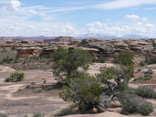
The carving of the many layers of sedimentary rock by two powerful, mighty rivers ... the Green and the Colorado ... has made the beautiful Canyonlands National Park. Only established as a National Park in 1964, it was the primitive domain of indians, cowboys, river explorers and prospectors. It still remains very wild .... and beautiful. We decided to enter the eastern region of the park .... the Needles.

We perused the Park Service printed materials, and found it somewhat amusing to read the following tip: "Avoid rocks which are moving toward your car."!
Our first stop was Newspaper Rock ... a very interesting set of petroglyphs.

As we moved more deeply into the park, we saw more and more interesting rock formations.


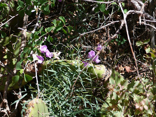
I thought this next picture was particularly pretty with some lovely blue wild flowers in the foreground.

After a brief visit at the Visitor Center (and gift shop, of course) we drove past the campground. We wanted to scope it out a little bit ... whenever we look for campsites in National Parks we are always frustrated as they do not seem to have sites that can accommodate any "camper" longer than 25 or 30 feet. Buster is 40 feet long. And Gary, in particular, wonders whether there really are sites that would work for us. Well, our assessment of the Needles Campground was that we really wouldn't fit anywhere. Hence, our camping down the road at Devil's Canyon!
We wanted to drive down to the Colorado River Overlook, but it was not advised unless you had a high clearance 4-wheel drive vehicle. Bella doesn't qualify. There were LOTS of jeep trails in Canyonlands, and we also so a lot of rock climbers.
We did drive to Big Spring Canyon Overlook,


and then we back-tracked to take the 2.5 mile Slickrock Foot Trail. I was a little apprehensive when I heard the word "slick", but it wasn't wet, and I had good, Nike shoes with some tread. It really was beautiful and fun. My knees did very well .... I just wish I'd eaten my packed sandwich like Gary and Liz did before the hike. I got REALLY hungry and started dragging with my fuel tank too low!


As we walked along we encountered a little lizard. Liz has taken a particular shine to desert lizards, and now wears an enamel pin depicting a collared lizard, and we call her Lizard sometimes. Well Gary wondered if he could get this little lizard to take a drink .... so he poured some water from his bottle on the ground and we watched. It just took a few moments for the little gal to hop down from her perch and take a drink.


We worried when Liz slipped over the edge, but she is a strong girl, and came back up just fine! (just kidding ..... we staged it!)

Finally, we found our best view of the Needles ..... those beautiful red rocks reaching to the sky as jagged teeth or uneven pillars .... needles!

It was a beautiful day, and we look forward to returning to the north region of Canyonlands ... Island in the Sky, off of Interstate 70 near Moab. We plan to visit there in mid-May, after we take our Colorado River rafting trip.
After another night at Devil's Canyon Campground, we retreated to Blanding on Saturday, April 17, where we had a great visit at the Edge of the Cedars Museum, also near an Ancestral Puebloan ruins. Wayne and Juanita had recommended we visit there, and they were right on. It was just a little gem of a museum. There were beautiful exhibits and we added another layer of understanding about the region. They also had a Junior Archeologist (!) program, which engaged Liz' attention. She completed this program and got a pin! It was here that Liz also got a little Collared Lizard enamel pin .... the first of a run of "lizard" shopping. We've taken to calling her this nickname while we're here in the desert and seeing lizards ALL THE TIME!
We turned west at state route 95 and headed toward Natural Bridges National Monument. The beautiful Manti-La Sal National Forest was on our right as we headed west.

There is a lovely loop road taking you by the beautiful bridges. They illustrate old, less old, and the youngest of these rock formations. Below is the mature Sipapu Bridge which is hard to spot at the overlook and in the picture. It is highest and greatest in span at 268 feet. Look about 4 o'clock in the mid-center of the photo.


Gary and Liz hiked down to get a closer look at the oldest bridge, Owachomo. It no longer has water or streams eroding it.


The youngest bridge was Kachina.
From Natural Bridges we continued along state 95 northwest to Hanksville, and crossing the Colorado River and the north end of the Lake Powell recreation area. At Hanksville we turned west onto 24 and travelled through Capitol Reef National Park to Torrey, Utah where we camped for two nights. It was, really, in the middle of nowhere but we had all the motorhome amenities: cell phone service, WiFi, and even cable TV!
The afternoon drive was beautiful; you can see we continue with our good weather karma!


Here is our approach to the Colorado River just south of Cataract Canyon, and below is Fruita, an early Mormon settlement of orchards and farms.


The historical Mormon town of Fruita sits right in the middle of the park, along the Fremont River.


The Castle
We ended the day with these images of Capitol Reef, intrigued to learn more about it the next day.
After a comfortable Saturday night with all the amenities (popcorn and cable TV!), we got up early on Sunday, April 18, to explore Capitol Reef National Park. I had never heard of it .... it takes it's name from what is called the "Waterpocket Fold" ... "a giant, sinuous wrinkle in the Earth's crust which stretches for 100 miles across south-central Utah." It is a buckling of rock that goes on for miles and miles.


100 miles of buckling rock!
It was fun to see this plaque about clean air ... I am always bragging about Minnesota and our clean air, but apparently the air of the Colorado Plateau takes the "best air" honors.
As we re-entered the Park from the west (Torrey), we came upon the Gooseneck overlook, looking down on the lazy turns the Fremont River takes hundreds of feet below.


Traveling east back toward Fruita, I was able to take this picture which, I think, really depicts the long waterpocket fold.

We stopped at the Visitor Center and heard the ranger giving a geology talk .... we came in part way through, but he was very good, and it was one of the better explanations I'd heard regarding the Colorado Plateau. They also passed out a map/chart which illustrates the various rock layers we were seeing, and Gary, especially, started wanting to identify everything from Moenkopi, to Kayenta, to Wingate sandstone. It can be very interesting, but very challenging, once you start wanting to understand the geology of Utah! The photo above shows some of the layers, but there are about 12 in some places, or maybe more! Gary also likes the petroglyphs, particularly the one on display in the Fruita Visitor Center .... it think it is the classic male shape .... broad shoulders, narrow hips .... that is so masculine, and it appeals to him.


Later, as we drove up the Grand Wash to get a glimpse of Cassidy Arch and Capitol gorge, we stopped for a little walk, and took some fun pictures against the sandstone. Gary's looking pretty much like a classic male, don't you think? What with the cowboy hat and the sprouting beard? (He's growing it for the raft trip.)


We also saw Cassidy Arch, thought to be one of the places Butch Cassidy and his gang hid out.

Finally, we saw the Golden Throne, a large yellow gold rock which is "out of place." Many of the capping rock layers are Navajo sandstone which is white. But this "throne" or monolith is yellow because of the staining of a darker former layer above.


The next day, Monday, April 19, we contemplated how we could see more of the waterpocket fold. There is a long, 127 mile loop tour that starts at the Visitor Center; and goes south (some of it dirt road), and connects with the Burr Trail and then over to Hwy 12, the scenic road down to Bryce through Grand Staircase National Monument. We took Hwy 12 south from Torrey to Boulder, passing the Boulder Mountain. Looking east we saw the Henry Mountains, some of the last mountains to be named on the continent. Looking further south, we see the desert mesas.


We got into a little snow again as we went over the Boulder Mountain pass, and then came down into the town of Boulder, Utah. It is a tiny town and one of the actual last outposts in the country. It was the last place to receive its mail by mule! We had lunch at the Burr Creek Grill where we had great burgers, Mexican coke, and Gary had a Polygamy Porter! (We are in Mormon Country!)


We then unhooked Bella, and drove her 72 miles (36 out and back) on the Burr Trail, some of which was unpaved.


We went as far as the Strike Valley overlook and could see down the dirt road switchbacks and decided we'd had enough: it was so desolate, it was almost a little scary.


In the distance, we saw more of that sinuous Waterpocket Fold with Boulder Mountain in the background.
Once we returned to Boulder, we rehooked Buster and Bella and continued south toward Escalante on Scenic Highway 12. We soon came upon The Hogback, a narrow crest of road with canyons falling away sharply on either side.

We passed the turn off to Hole in the Rock Road, and came through Grand Staircase-Escalante National Monument. As I mentioned earlier, this refers to the layers of rock that start up at higher elevations in the Colorado Plateau (like Bryce where it snowed when we were there) and staircase down. When early geologists saw the series of cliffs and plateaus rising 6,000 feet from the Kaibab Plateau at the North Rim of the Grand Canyon to Bryce Canyon, they called it the Grand Staircase. Each of the five "steps" has been eroded, revealing cliffs of distinctive color. It was made a National Monument in September, 1996, and its 1.9 million acres of land is the first national monument administered by the Bureau of Land Management and not the National Park Service.
As we neared Bryce we came upon a last towering rock: Powell's Point. On John Wesley Powell's second expedition in 1872 he and his party explored the Green and Colorado Rivers, and into the Paria River Valley. He then asked his brother-in-law Almon Thompson to travel overland and chart the inland territory. This very remote land was part of that expedition.

Also at the Powell Point overlook was this great illustration of the inland sea that existed before the plates crashed into each other and caused the Colorado Plateau to rise.

From Powell's Point, we drove on to the turn off to Bryce Canyon, and found our way into Ruby's ..... a longtime Bryce hotelier! Gary and Liz had been longing to have a cookout and tonight was the night .... in 40 degree temperatures! I ate mine inside warm and toasty Buster!
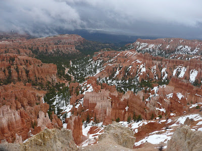
Bryce Canyon is pretty high .... the Visitor Center is at nearly 8,000 feet. So when the spring weather turned in a little precipitation, it snowed in Bryce. It was really chilly and cloudy all day on Tuesday, April 20.
Ruby's has an interesting history. In 1916, Rueben C. (Ruby) Syrett brought his family to the wilds of Southern Utah, establishing a ranch here. A few weeks later another rancher told Ruby about Bryce Canyon and he and his family made a Sunday trip to the rim. They were so impressed with what they saw, they invited friends and family to visit, and soon had a steady stream of visitors. Ultimately, they became THE hosts of people visiting Bryce Canyon.
We went over to the Lodge at Ruby's to make some phone calls: scheduling a CPR course in Las Vegas for Gary so he can renew his dental license (he is going back to work in July after all), making reservations at the Residence Inn in Las Vegas for us to stay a couple of days after our raft trip. In the afternoon, it was clear enough for Liz and Gary to go for a horseback ride. They bundled up in about 4 layers each, found gloves and hats, and had a great time.


Wednesday, April 21 began as a most pathetic day for me. We woke up to cold/sleet/and snow, and I felt just pitiful. It had fallen to 25 degrees the night before. We had had to unplug our water connection (something we hadn't done since January) in order to avoid freezing of the input line and use our propane heat, which is the only effective heat we have in temperatures less than 35 degrees. I had a miserable combination of common afflictions: migraine, sore throat, athlete's foot, and shortness of breath (I'm not sure whether it was from altitude or anxiety). I Emailed my colleagues at Women's HealthSource and said I just wasn't up to any editing work, and they were very compassionate and understanding. When we got our courage up, we took an hour's drive into the park (Bryce Canyon National Park) and took a few pictures from overlooks, but no real exploring for us today. We had a nice lunch at the Bryce Canyon Lodge (Liz had remained in her PJs!), and another nice visit to the Gift Shop. (It doesn't look like Gary's having that good a day, either, does it?) Slowly, my symptoms improved.


We were a little disappointed that weather had impacted our visit to Bryce; I had remembered it for decades .... we stopped there with my family when we drove out to California when we moved there from Ohio in 1958. It is, obviously, simply gorgeous!
On Thursday, April 22, we were happy to see that it had warmed up to around 33 degrees as one thing we really didn't want to encounter was ice or snow on the road. We continued on Highway 12, but planned to turn north on 89 and then take 20 over to I15. Below you'll see a pretty arch tunnel we passed under on Highway 12, and then the view north as we headed, briefly, up 89 .


We had been warned that we shouldn't take 89 south in Zion because of a tunnel which was a difficult large motorhome passage. And besides, we wanted to stop in Cedar City to see the playing (basketball) home of our son-in-law, Chris Jones.
Chris attended Southern Utah University in the early 90's on a basketball scholarship and played for the Thunderbirds in the Centrum. It is a BEAUTIFUL arena, and you can see the fabulous basketball court. We had a great time scouting out SUU fan shirts for all the Jones' kids, and had the honor of getting the twins their first SUU t-shirts!


From Cedar City, we headed down I15 to the Zion Park cut off. We were hopeful that we were going to meet up with Camilla Mohn, the sweet little sister of my former sister-in-law Celeste de Tessan. Camilla and her daughter Marisa live in Las Vegas where Camilla has carved out a very nice career as a mortgage broker. They love hiking and hoped to meet us in Zion for the week-end.
So we spent our first night in Springdale at the Zion Campground, and then we had the disappointing EMail from Camilla that next morning .... she had had a complicated week and just couldn't work it out to come up for the week-end. We were disappointed, but knew we'd get to see her when we got to Las Vegas before the raft trip.
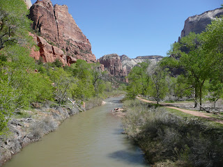
Zion is at an intermediate elevation between Bryce and the Grand Canyon, at about 4,000 feet. Its gathered waters, known as the Virgin River, traverse Mojave Desert lands and join the Colorado in Lake Mead's manmade basin before completing their Pacific-bound journey.

Travel up the main canyon is closed to car traffic .... one boards a shuttle bus and is dropped off at various view and hiking trail heads. We decided to ride the shuttle the next day, on Saturday, and drive through the 1.1 mile Mt. Carmel tunnel. We saw the East Temple as we drove east through the park.


The lighter color rock is the younger layer of Navajo sandstone. Near the east entrance we saw Checkboard Mesa (on the right).


Then we turned around and drove back to the tunnel passing some pretty "rock" flowers!


Liz stayed in the car while Gary and I took the 1 mile Canyon Overlook trail.


Some kind folks took our picture underneath a ledge, and then we reached this broad vista. The two peaks to the right are the Altar of Sacrifice and The Streaked Wall.


As we walked back we could see where an opening had been made in the tunnel for light (on right), and then a car exiting.


Later we had a chance to see some of these towering rocks up closer: the Towers of the Virgin and the Altar of Sacrifice.

After we left the park, we went into Springdale, the town bordering the south park entrance, looking for some milk to buy. And, low and behold, we found this darling store with a cute name. We got some beaded sandals and bags, Liz got a beautiful white sundress, and I got a white, rhinestoned floppy hat that will be great for the river. We love Zion!

On Saturday, April 24, we explored Zion Canyon, along the Virgin River, using the Park's shuttle bus. It was very convenient.

We got on at the Visitor's Center, and picked out some maps and books that we wanted to consider later. Then we stopped at the Zion Human History Museum and saw the always interesting and informative orientation movie. We also picked up a little guidebook for flower identification which proved very useful later in the morning.
We hopped back on the shuttle and started snapping pictures on what, very possibly, was the most gorgeous day we've experienced on our trip. I've always adored spring and newly leafy trees ... you'll see we saw them everywhere today.

We stopped at the Zion Lodge, got a Latte, and started our walk up to the Emerald Pools.


While the pools are not exactly Emerald (but more "monkey-vomit greenish"), the falling water was beautiful.


We hiked back from the Emerald Pool to The Grotto,


and on the way stopped to try to identify some beautiful spring flowers:

We captured some more lovely images on the way to the Grotto.


Back on the shuttle, we passed Angel's Rest (below)

and made our way to the Temple of Sinawa to take the Riverside Walk up to the Narrows. This is a flat walk along the Virgin River canyon, until it gets so narrow that you can only continue if you walk up the canyon in the water ... I believe as much as 10 or more miles. This wasn't permitted on the day we were there because the river was running so fast. It also looked very difficult as the rocky bottom of the river was irregular and slippery.


Here is (kind of) a picture of what the river looks like in The Narrows, and of Gary and me as we stood by the river.


The walk back along the river was equally lovely.


We saw some rock climbers

and then ended our day with a stop at the Court of the Patriarchs, from left Abraham, Isaac, and Jacob in the right rear. Moroni is in the right foreground.

We picked up our books at the Visitor Center, and then went back to the campground. Gary did laundry while Liz and I went out to Pizza and Noodles .... we really had to negotiate what we wanted to get, as they didn't take credit cards and we only had $27 in cash .... not enough for two salads and two pops with our pasta or pizza. We got by!
We felt we had really had a wonderful experience on the Colorado Plateau, and learned so much, and saw so much beautiful rock. We looked forward to returning after our river raft trip and see some more of these beautiful Utah rocks.
The first phase of our Colorado River adventure would begin the next day.
Stay tuned!
Julie, Gary and Liz
No comments:
Post a Comment